Mostrando entradas con la etiqueta Spain. Mostrar todas las entradas

sábado, 4 de marzo de 2017

Definitions for Social Science Unit 3

Hydrography—The geographical study of the waters of the Earth.
Tributary (afluente)—A river that flows into another river instead of draining into the sea.
Source (nacimiento)—Where the water emerges from the earth to become a river
Mouth (desembocadura)—where the river ends
Channel (cauce)—where the river flows
Course (curso)—the path a river follows
Meanders—the curves in a river
Length—the distance between a river’s source and mouth
Discharge (caudal)—the amount of water flowing through a river
Regime (régimen)—the discharge variation throughout the year
Drainage basin (vertiente)—An area of land that drains all of its water into the same ocean, sea, or sometimes lake.
Dam (presa)—Dams are built on rivers to create reservoirs.
Reservoir (embalse)—water collected for human use (consumption, irrigation, industrial use, or to generate energy)
Torrents—Natural, flowing streams of water created by rain.
Ravines—Deep, narrow, steep-sided valleys formed by running water

viernes, 24 de febrero de 2017

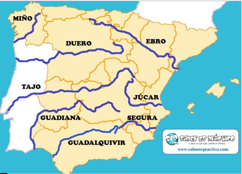
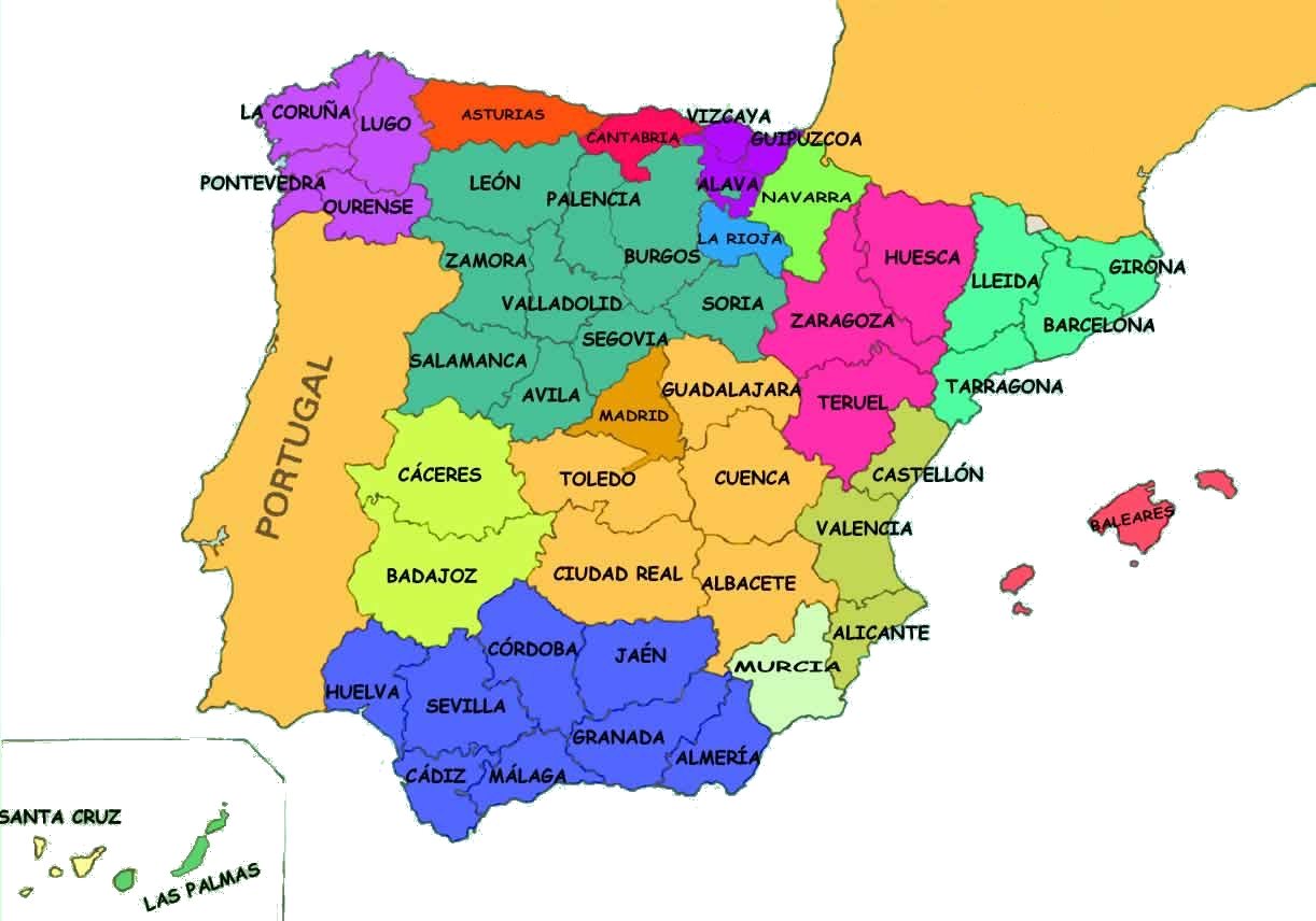
Map of rivers and provinces

This map shows the main rivers of Spain. You have to know about them: their source, their mouth, and the provinces they cross.

In this map you can also see the outlines of the autonomous communities. This can help you visualise the provinces.

https://luisamariaarias.files.wordpress.com/2012/11/principales-rc3ados-de-espac3b1a.jpg

https://socialesynaturalesfllopis.files.wordpress.com/2013/11/mapa_espana_provincias-6.jpg

Hydrography of Spain

In this presentation you can see lots of photos of the different rivers in Spain. It also has coasts, lakes, lagoons, dams, and reservoirs.


domingo, 19 de febrero de 2017

Social Science Test Unit 3

You know that this Thursday (23rd February) you have the test on the rivers from your map. It will be worth 2 points on your unit test.

You will have a test on the rest of Unit 3 on Wednesday, 8th March.

Here is what you have to study:

--the definitions from your notebook
--Name and explain the elements of a river
--Name and explain the characteristics of a river
--Explain the two factors that determine a river's characteristics
--Characteristics of the rivers in the three drainage basins of Spain
--Important information about five important rivers of Spain (Duero, Tajo, Guadiana, Guadalquivir, Ebro). Include: source, mouth, and provinces it crosses

Here is an article about torrents in Mallorca at the end of January due to heavy rains.  Another article shows how the reservoirs were overflowing.


lunes, 13 de febrero de 2017

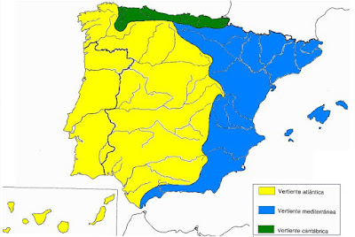
Drainage basins in Spain

Here is a map of the three drainage basins in Spain:

https://blogger.googleusercontent.com/img/b/R29vZ2xl/AVvXsEg-AZQEbtuxTc75jpzqiRj3Bn_p81bwvJ6vWVhBGYjHs-bYmrUBlA4AggSzH-1fSo5WzD7IRqA7SSvGGu9TnRQiqjdGyAr9YN0rUqbLlxLEgHj_HsjA2PQODy-KOyrLmxED2iF-4Z-ZC9m4/s1600/mapa.jpg

Can you explain the main characteristics of the rivers in each?

Watch this about rivers.

Locate the rivers on the map!

Another map game


One more map game

Some information in Spanish:

Ríos


Vertientes Españolas

domingo, 29 de enero de 2017

Social Science Test Units 1&2

Your Social Science test will be on Wednesday, 8th February.

You will have to label on a map:  

Capes:  Peñas, Fisterra, Creus, Palos, Gata and Nao.
Gulfs: Bizkaia, Valencia and Cádiz. Mar Menor and Strait of Gibraltar
Inland relief: Galician Massif, Cantabrian Range, Northern Sub-Plateau, Mountains of León, Basque Mountains, Catalan C. Range, Pyrenees, Iberian System, Sierra Morena, Central System, Southern Sub-Plateau, Toledo Mountains, Ebro Depression, Guadalquivir Depression, Penibaetic Range, Subbaetic range, Gredos, Somosierra, Guadarrama, Picos de Europa, Sierra Nevada, Tramuntana Range, Teide Peak, Almanzor Peak, Moncayo Peak, Aneto Peak, Torreceredo Peak and Mulhacén Peak.

Islands: Menorca, Formentera, Mallorca, Ibiza, La Palma, El Hierro, La Gomera, Tenerife, Gran Canaria, Lanzarote and Fuerteventura.

Here you can practice land relief of Spain:


Here you can practice features of the coast:


You also need to know the information from the book that we studied and underlined about the Meseta, the mountain ranges, depressions, land forms: delta, salt marshes, campiñas, coastal bench, rías, coastal wetlands, freshwater lagoons, land relief of the islands, factors that determine coastal features (land relief, tides, coastal erosion).

Review again the questions we have discussed in class.

domingo, 11 de diciembre de 2016

Social Science review questions

On Wednesday you have your last test of the trimestre: Social Science!  You must be able to locate and label all of the provinces of Spain (I will give you a list.)

Also you must study about how our government is organised. Here are the review questions to help you. All of the answers are in your book.

1. What is the city council formed by?
2. What are the three bodies of government within an autonomous community?
3. What is the Statute of Autonomy?
4. Name four things included in the Statute of Autonomy?
5. How does the Constitution define Spain? Where does its sovereignty reside?  How is it organized?
6. How many autonomous communities are in Spain?
7. Name the two autonomous cities.
8. What are the State Institutions established by the Constitution?
9. What is the function of the Head of State?  Who is it?
10. Which institution holds the executive power?  What is its mission? What is it formed by?
11. What is the Parliament in charge of?  What kind of power do they hold?            What are its two chambers?
12. Which institution holds the judicial power? What are they in charge of?             What are the main courts of justice in Spain?

jueves, 1 de diciembre de 2016

Line of succesion to the Spanish throne

In class today some of you were asking about the line of succession to the throne. We learned that the Head of State (executive power) is the King, in this case Felipe VI.

The line of succession is part of the Constitution. You can read it here:

Article 57 of the Spanish Constitution.

Here is a graphic:

Image credit   (you can read the article)


Some people want to change this article of the Constitution because it discriminates against women. But in order to change the Constitution, a long process must be followed, including a referendum (the people have to vote.)   Maybe it will happen someday!

Suponiendo que Felipe VI propusiera alguna de estas reformas y las fuerzas políticas atendieran su petición, primero se haría una votación en las Cortes para aprobar el inicio de la reforma de la Constitución. Posteriormente, habría que disolver las cámaras y celebrar elecciones. Se volvería a constituir el Congreso y el Senado y las Cámaras deberían decidir si se sigue adelante con la reforma y si así fuera deberían discutir y redactar el nuevo texto. Más tarde, sería imperativo la aprobación de esa nueva redacción mediante referéndum.

Ver más en: http://www.20minutos.es/noticia/2169263/0/reforma-constitucion/baza-felipe-vi-reto/regenerar-monarquia/#xtor=AD-15&xts=467263


sábado, 26 de noviembre de 2016

Autonomous communities and provinces

We will have the last Social Science test of the trimestre on Wednesday, 14th of December. It will be on Unit 6: Spain's Organisation. 

Half of the test grade will be to locate and label on a map the Autonomous Communities and provinces in Spain.  You can practise using the activities in this link:

Interactive Maps   

(This may not work on a tablet.)


https://contentmapas.didactalia.net/imagenes/Documentos/ImagenesSemanticas/7b5ac936-01da-46f0-a000-58e9564c20ae/26bc54dc-5ab2-4c35-95bd-41719a2b05b8.jpg

Don't forget the Autonomous cities, Ceuta and Melilla!


It can be an easy way to improve your Social Science grade, but you should start to study now!


martes, 22 de noviembre de 2016

20th Century Spain

Here is a Power Point to help you study for your test.


20th century Spain from Kathleen Marcy

Here is a link to a page that has many activities (in Spanish) to help you understand or to get morer information.

Good luck!

sábado, 27 de febrero de 2016

My project!

Here is my example for the architecture project.

This is the Iglesia de San Miguel in Arcones, Segovia. 


It was built in the 13th Century AD.  It is in the Romanesque style. It has thick walls and small windows. It is made of stone and has some doors and a window with a rounded arch. 


The original structure has been modified in some ways but it still has some original elements.


martes, 23 de febrero de 2016

Now it's your turn!

Now you have to find information about a church in Spain. It can be a small church from a village or a big cathedral.  Give information about it:  

--Where is it?
--When was it built?
--What architectural style is it?
--What are the characteristics of this style?

Put your information on an A4 card (cartulina tamaño folio) and include pictures!

Due: Tuesday, 1st of March.

domingo, 25 de octubre de 2015

Unit 2 Test, Social Science

Our test on Unit 2: Coastal landscapes and rivers in Spain, will be on Friday, 30th October.  Here is what you need to study:

--All of the words on the Word List on page 29 (be able to give a definition for each.)
--Place the coasts on a map and give their characteristics.
--Label ALL of the features I gave you on your map (capes, rivers, bodies of water...)
--Characteristics of the rivers in each drainage basin.
--Some examples of rivers from each drainage basin (you should be able to name at least two for each.)
--An example of a river that is a tributary.

Also, be sure you can answer the questions in your book from this unit.

Good luck!  Don't forget, on this page you can find interactive maps to help you study.


domingo, 11 de octubre de 2015

Spain's coasts


Can you describe these coasts?   

Rocky or sandy beach?


Cliffed or flat?


Uneven or straight?


Please study the five Spanish coastlines and their characteristics.  Can you make a mind map? Add in the characteristics below each coastline.


Interactive maps of Spanish coastlines and features: Where is it?   And, What's it called?


Here's a short video with aerial photos of Spain. Can you describe the coasts in the video?


viernes, 2 de octubre de 2015

Depressions

The Ebro Depression is a large, triangular plain in the northeast of the peninsula. The river deposits materials near the mouth, creating a delta.


The Guadalquivir Depression is a large, triangular plain with fertile marshes near the mouth of the river.


miércoles, 23 de septiembre de 2015