Mostrando entradas con la etiqueta geography. Mostrar todas las entradas

domingo, 26 de marzo de 2017

Social Science Test Unit 4

You will have one more Social Science test before the break-- Unit 4.  It will be Wednesday, 5th April.

You will have to write the definitions of the vocabulary (inlet, peninsula, gulf, cape, island, fjord, ría).

You must know the boundaries of Europe (seas, oceans, mountains, continent).

You must describe the topography of inland Europe (it is relatively simple!)  and of the European coastline (two parts).

Where are the plains?  What are Massifs? Where are they located?   What are plateaus? Where are the highest mountain ranges? Give some examples.  And the smaller mountains? 

Label the map:

http://maplists.com/wp-content/uploads/blank-map-of-europe-in-1815-53090536.jpg

Link to page with the map (it's the seventh map on the page)


Mountains Ural, Caucasus, Scandinavian, Grampian, Alps, Carpathian, Balkan, Pyrenees, Dinaric Alps, Apennines
Peninsulas: Kola (not on the map), Crimean, Iberian, Balkan, Italian, Scandinavian, Jutland
Islands: Sardinia, Sicily, Sardinia, Crete, Cyprus, British Isles, Iceland. Balearic
Capes:  North, Saint Vicent, Matapan, Fisterra
Gulfs:  Bothnia, Bizkaia, Lion, Genoa
Plains.  Russian, Great European Plain
Seas:  Mediterranean, Black, Caspian, Adriatic, North, Baltic, Cantabrian,Tyrrhenian.
Oceans: Atlantic, Artic
Peaks: Mont Blanc, Elbrus, Mulhacén, Aneto
Other: Strait of Gibraltar, English Channel, Asia, Africa

jueves, 16 de marzo de 2017

Social Science Unit 4

We will have one last Social Science test before the holidays. It will be on Unit 4, Landforms and territories of Europe.

http://maplists.com/wp-content/uploads/detailed-physical-map-of-europe-27813651.jpg

You must know several definitions and also the map.   Locate on the map:


Mountains:  Ural, Caucasus, Scandinavian, Grampian, Alps, Carpathian, Balkan, Pyrenees, Dinaric Alps, Apennines, Massif Central
Peninsulas:  Kola, Crimean, Iberian, Balkan, Italian, Scandinavian, Jutland
Islands: Sardinia, Corsica, Sicily,  Crete, Azores, Cyprus, British Isles, Iceland. Balearic
Capes:  North, Saint Vicent, Matapan, Fisterra
Gulfs:  Bothnia, Bizkaia, Lion, Genoa
Plains.  Russian Plain, Great European Plain
Seas:  Mediterranean, Black, Caspian, Adriatic, North, Baltic, Cantabrian,Tyrrhenian.
Oceans: Atlantic, Artic
Peaks: Mont Blanc, Elbrus, Mulhacén, Aneto

Other: Strait of Gibraltar, English Channel, Asia, Africa

Map games to practice:

European Relief (What is it called?)
European Relief 2 (Where is it?)
Coasts of Europe 1 (What is it called?)
Coasts of Europe 2 (Where is it?)

The maps about the coasts have a lot of information that you don't need to memorise, but you can use the  "Mirar" feature (instead of "Jugar") to practice!

After Semana Santa we will start to learn the countries of Europe (political map!)

Here is a presentation about Physical Geography of Europe. It includes rivers and climate (which we will learn about later!)

sábado, 4 de marzo de 2017

Definitions for Social Science Unit 3

Hydrography—The geographical study of the waters of the Earth.
Tributary (afluente)—A river that flows into another river instead of draining into the sea.
Source (nacimiento)—Where the water emerges from the earth to become a river
Mouth (desembocadura)—where the river ends
Channel (cauce)—where the river flows
Course (curso)—the path a river follows
Meanders—the curves in a river
Length—the distance between a river’s source and mouth
Discharge (caudal)—the amount of water flowing through a river
Regime (régimen)—the discharge variation throughout the year
Drainage basin (vertiente)—An area of land that drains all of its water into the same ocean, sea, or sometimes lake.
Dam (presa)—Dams are built on rivers to create reservoirs.
Reservoir (embalse)—water collected for human use (consumption, irrigation, industrial use, or to generate energy)
Torrents—Natural, flowing streams of water created by rain.
Ravines—Deep, narrow, steep-sided valleys formed by running water

viernes, 24 de febrero de 2017

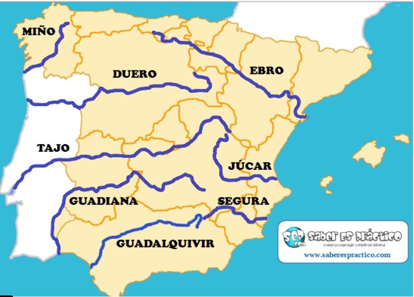
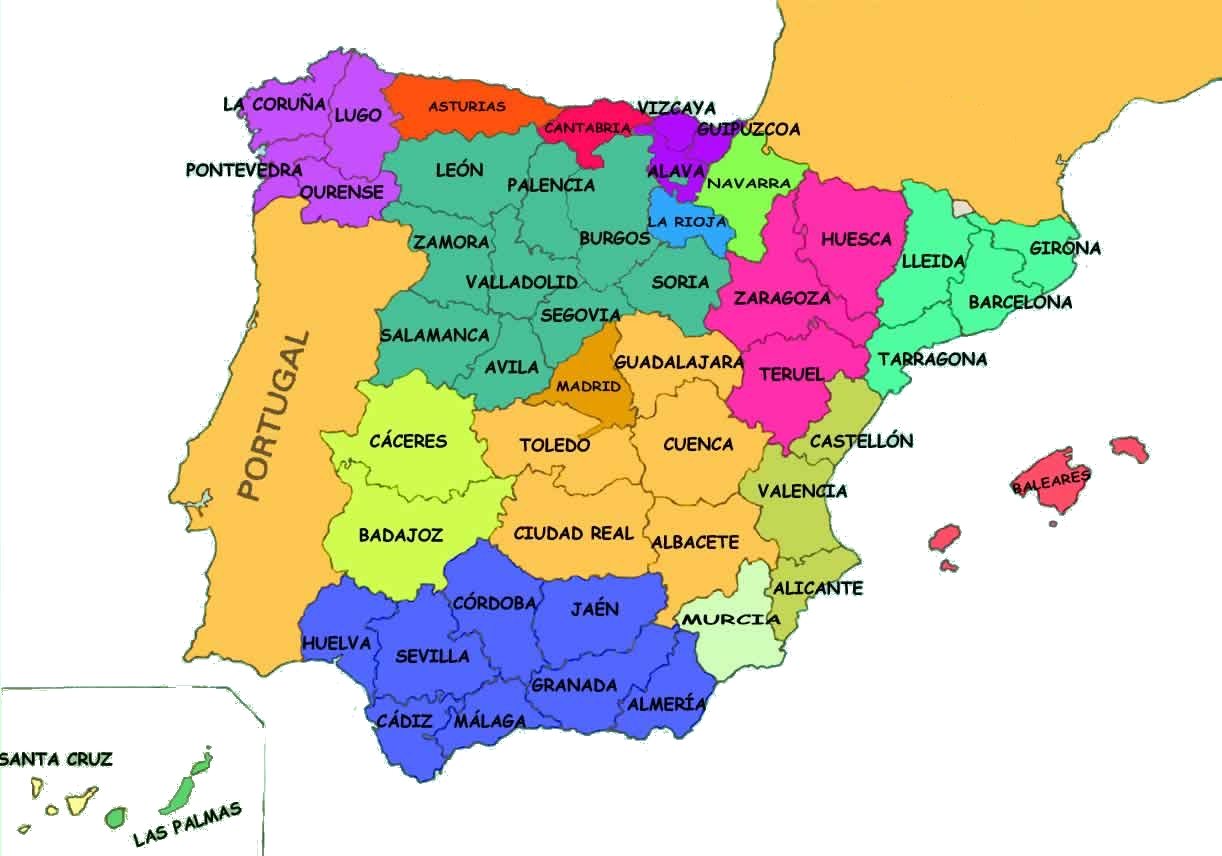
Map of rivers and provinces

This map shows the main rivers of Spain. You have to know about them: their source, their mouth, and the provinces they cross.

In this map you can also see the outlines of the autonomous communities. This can help you visualise the provinces.

https://luisamariaarias.files.wordpress.com/2012/11/principales-rc3ados-de-espac3b1a.jpg

https://socialesynaturalesfllopis.files.wordpress.com/2013/11/mapa_espana_provincias-6.jpg

Hydrography of Spain

In this presentation you can see lots of photos of the different rivers in Spain. It also has coasts, lakes, lagoons, dams, and reservoirs.


domingo, 19 de febrero de 2017

Social Science Test Unit 3

You know that this Thursday (23rd February) you have the test on the rivers from your map. It will be worth 2 points on your unit test.

You will have a test on the rest of Unit 3 on Wednesday, 8th March.

Here is what you have to study:

--the definitions from your notebook
--Name and explain the elements of a river
--Name and explain the characteristics of a river
--Explain the two factors that determine a river's characteristics
--Characteristics of the rivers in the three drainage basins of Spain
--Important information about five important rivers of Spain (Duero, Tajo, Guadiana, Guadalquivir, Ebro). Include: source, mouth, and provinces it crosses

Here is an article about torrents in Mallorca at the end of January due to heavy rains.  Another article shows how the reservoirs were overflowing.


lunes, 13 de febrero de 2017

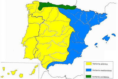
Drainage basins in Spain

Here is a map of the three drainage basins in Spain:

https://blogger.googleusercontent.com/img/b/R29vZ2xl/AVvXsEg-AZQEbtuxTc75jpzqiRj3Bn_p81bwvJ6vWVhBGYjHs-bYmrUBlA4AggSzH-1fSo5WzD7IRqA7SSvGGu9TnRQiqjdGyAr9YN0rUqbLlxLEgHj_HsjA2PQODy-KOyrLmxED2iF-4Z-ZC9m4/s1600/mapa.jpg

Can you explain the main characteristics of the rivers in each?

Watch this about rivers.

Locate the rivers on the map!

Another map game


One more map game

Some information in Spanish:

Ríos


Vertientes Españolas

domingo, 29 de enero de 2017

Social Science Test Units 1&2

Your Social Science test will be on Wednesday, 8th February.

You will have to label on a map:  

Capes:  Peñas, Fisterra, Creus, Palos, Gata and Nao.
Gulfs: Bizkaia, Valencia and Cádiz. Mar Menor and Strait of Gibraltar
Inland relief: Galician Massif, Cantabrian Range, Northern Sub-Plateau, Mountains of León, Basque Mountains, Catalan C. Range, Pyrenees, Iberian System, Sierra Morena, Central System, Southern Sub-Plateau, Toledo Mountains, Ebro Depression, Guadalquivir Depression, Penibaetic Range, Subbaetic range, Gredos, Somosierra, Guadarrama, Picos de Europa, Sierra Nevada, Tramuntana Range, Teide Peak, Almanzor Peak, Moncayo Peak, Aneto Peak, Torreceredo Peak and Mulhacén Peak.

Islands: Menorca, Formentera, Mallorca, Ibiza, La Palma, El Hierro, La Gomera, Tenerife, Gran Canaria, Lanzarote and Fuerteventura.

Here you can practice land relief of Spain:


Here you can practice features of the coast:


You also need to know the information from the book that we studied and underlined about the Meseta, the mountain ranges, depressions, land forms: delta, salt marshes, campiñas, coastal bench, rías, coastal wetlands, freshwater lagoons, land relief of the islands, factors that determine coastal features (land relief, tides, coastal erosion).

Review again the questions we have discussed in class.

lunes, 4 de abril de 2016

Spanish colonisation of the Americas

In the first stage of Spanish colonisation of America, there were two important conquistadors.

Hernán Cortes conquered the Aztecs in Mexico:


And Francisco Pizarro conquered the Incas in Peru.


Here is a map of the two Viceroyalties:


Trade between Europe and the Americas:

http://player.slideplayer.com/15/4598800/data/images/img1.jpg


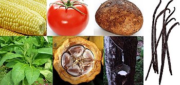
New crops were introduced to Europe:

https://upload.wikimedia.org/wikipedia/commons/thumb/d/d0/New_World_Domesticated_plants.JPG/350px-New_World_Domesticated_plants.JPG


But the Spanish also brought diseases, and forced the indigeneous people into slavery in order to exploit resources such as gold and silver.


viernes, 16 de octubre de 2015

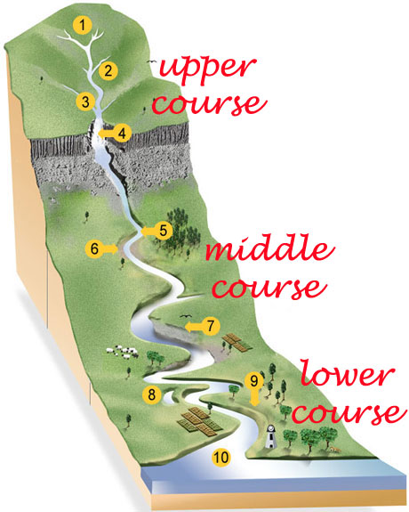
Rivers

Do you remember the parts of a river?

https://arts2science.files.wordpress.com/2014/09/rivers02parts2.jpg?w=460&h=575


http://www.sln.org.uk/geography/schools/blythebridge/images/GCSERe7.jpg


Here are some games to study the location and names of the rivers.

Where is it?
What is it called?

Remember, you have to complete your map with the rivers, capes, etc.  and bring it on Tuesday (Monday we will do Natural Science instead.)


domingo, 11 de octubre de 2015

Spain's coasts


Can you describe these coasts?   

Rocky or sandy beach?


Cliffed or flat?


Uneven or straight?


Please study the five Spanish coastlines and their characteristics.  Can you make a mind map? Add in the characteristics below each coastline.


Interactive maps of Spanish coastlines and features: Where is it?   And, What's it called?


Here's a short video with aerial photos of Spain. Can you describe the coasts in the video?


viernes, 2 de octubre de 2015

Depressions

The Ebro Depression is a large, triangular plain in the northeast of the peninsula. The river deposits materials near the mouth, creating a delta.


The Guadalquivir Depression is a large, triangular plain with fertile marshes near the mouth of the river.


jueves, 1 de octubre de 2015

Unit 1 Social Science Test review

Your test is on Monday!  Here are some questions to help you study. Use complete sentences in your answers.

P. 8, 9    Spain’s location and landscape
1. What is Spain formed by?
2. What are its borders?
3. What covers a large part of the peninsula and archipelagos?
4. What is the coastline of Spain like?
5. What is at the center of the peninsula?

p. 10, 11   The Meseta and its mountain systems
6. What is the Meseta almost surrounded by?
7. What communities does it cover?
8. What are the two mountain systems on the Meseta?
9. The rivers that pass through the Meseta empty into which ocean?
10. Which sub-plateau is bigger, flatter, and higher?
11. What are the main mountain ranges in the Central Sierra?  Locate them on the map.
12. What is the highest peak in the Central Sierra?
13. How many mountain systems surround the Meseta? Name them.

p. 12, 13   The mountain systems outside the Meseta
14. How many mountain systems are outside the Meseta? Name them.
15. What are the two parallel ranges in the Baetic mountain system?
16. Name and describe the two large depressions outside the Meseta.

General questions:
17. Name three Peaks.
18. Name three mountain systems.
19. Name three mountain ranges.


Locate on the map all of the things on your list.


Good luck!!!!

miércoles, 23 de septiembre de 2015